In the ever-changing environment of urban energy management, District Heating and Cooling (DHC) systems play a critical role in lowering carbon emissions and increasing efficiency. These systems, which distribute thermal energy via a network of insulated pipes, are an essential component of sustainable urban planning, particularly in Smart Energy Districts. With the growing complexity of energy grids, advanced digital techniques such as Building Information Modelling (BIM) and Geographic Information Systems (GIS) have become critical for modernising DHC network planning. In this regard, the HYPERGRYD project, which is supported by the European Union’s Horizon 2020 programme, uses a BIM-GIS toolset to improve the efficiency, accuracy, and adaptability of DHC networks. This article explores how the BIM-GIS integration revolutionises the design, operation, and management of DHC systems, offering engineers, urban planners, and energy professionals a glimpse into the future of Smart Energy Districts.
The Growing Importance of DHC Systems in Urban Energy Networks
District Heating and Cooling (DHC) systems have long been regarded as an efficient method of supplying thermal energy to various buildings throughout a city. These systems can improve energy efficiency and minimise greenhouse gas emissions by centralising heating and cooling production and distributing it over an insulated pipe network. Modern DHC networks, particularly 4th and 5th generation systems, are intended to absorb renewable energy sources (RES) and waste heat, making them critical components of any smart energy solution. However, as cities grow and urban energy demands become more complicated, new technologies for planning, optimising, and monitoring these networks become increasingly important. This is where BIM and GIS integration comes in, allowing engineers and planners to better manage the spatial and technological components of DHC networks.
Understanding BIM and GIS in the Context of DHC
Building Information Modelling (BIM)
Building Information Modelling (BIM) is a digital representation of a building’s physical and functional attributes. It enables the generation and management of comprehensive 3D models that may be used across a project’s lifecycle, from planning and design to operation and maintenance. BIM allows stakeholders to work more effectively together, ensuring that all parts of a building’s design, construction, and operation are properly integrated. In the context of DHC networks, BIM is utilised to simulate the heating and cooling infrastructure components. This involves the design of pipes, heat exchangers, and energy sources, as well as the buildings that connect to the network. By including specific information about materials, dimensions, and operational factors, BIM ensures that the DHC infrastructure is optimised for efficiency and longevity.
Geographic Information Systems (GIS)
GIS is a technology used to capture, store, analyse, and manage spatial data. In urban planning and infrastructure development, GIS plays a crucial role in visualising and managing geographic information. This includes everything from land use and zoning to topography and underground utilities. For DHC systems, GIS provides the spatial context needed to plan network routes, optimise energy flow, and assess the environmental impact of the infrastructure. By integrating GIS with BIM, planners can ensure that the layout of DHC networks aligns with the geographic and environmental characteristics of the area, taking into account factors such as terrain, existing utilities, and building density.
The BIM-GIS Integration: A Game-Changer for DHC Network Planning
While BIM and GIS have traditionally been used independently in infrastructure planning, their integration offers significant benefits for DHC network design and management. The BIM-GIS toolkit developed as part of the HYPERGRYD project provides a unified platform that allows engineers and planners to combine the technical detail of BIM models with the spatial intelligence of GIS. This integration revolutionises the way DHC systems are planned, offering several key advantages:
1. Optimised Network Layouts
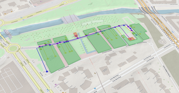
One of the most critical aspects of DHC network planning is determining the optimal layout of pipelines and other infrastructure components. Traditionally, this process involved manually mapping out the network, which could lead to inefficiencies and costly errors. With BIM-GIS integration, planners can use GIS data to assess the geographic characteristics of the area and then overlay the BIM model of the DHC system to design a network layout that maximises efficiency. For example, the BIM-GIS toolkit allows planners to visualise how pipelines will be laid out in relation to existing utilities, roads, and buildings. This ensures that the network is designed to minimise disruption, reduce installation costs, and optimise energy flow. Additionally, planners can use the toolkit to simulate different network configurations and assess their impact on energy efficiency, helping to identify the most cost-effective solution
2. Enhanced Decision-Making
By providing a comprehensive view of both the physical infrastructure and the surrounding environment, the BIM-GIS toolkit enhances decision-making throughout the planning and operational phases of a DHC network. Engineers and urban planners can use the integrated platform to run simulations, analyse data, and make informed decisions about network design and operation.
For instance, the toolkit can be used to assess the impact of different energy sources, such as solar thermal, geothermal, or waste heat, on the network’s performance. Thanks to its integration with third-party services like ENCO’s SAInt (Scenario Analysis Interface for Energy Systems) and GET’s Exergoeconomic Optimization Tool for 4th and 5th Generation of DHC, the BIM-GIS toolkit enables planners to simulate energy flows and thermal dynamics with even greater precision. The SAInt tool allows for advanced modelling and simulation of both thermal and electrical networks, while the Exergoeconomic tool provides critical insights into the cost and exergy efficiencies of the energy system. By leveraging these integrations, planners can optimise the integration of renewable energy sources, ensuring that the DHC network operates at peak efficiency while minimising costs and energy losses. Moreover, the toolkit enables real-time monitoring of the network, allowing operators to make adjustments based on current conditions. This level of visibility and control is particularly important for modern DHC systems, which need to be highly adaptable to fluctuations in energy demand and supply.
3. Improved Collaboration and Communication
BIM-GIS integration facilitates better collaboration and communication among stakeholders involved in DHC network planning. With a unified platform, engineers, planners, utility companies, and policymakers can access the same data and models, ensuring that everyone is working from a common understanding of the project. This improved communication is particularly valuable in large-scale urban projects, where multiple stakeholders must coordinate their efforts to ensure the successful implementation of the DHC system. The BIM-GIS toolkit allows stakeholders to share models, run simulations, and make joint decisions based on accurate, real-time data. This reduces the risk of miscommunication, delays, and costly revisions.
4. Cost and Resource Efficiency
One of the key goals of integrating BIM and GIS in DHC network planning is to improve resource efficiency. By using the BIM-GIS toolkit to optimise network design and operation, planners can reduce the overall cost of installing and maintaining the DHC system. For example, by accurately mapping out pipeline routes and using GIS data to avoid obstacles, planners can minimise the amount of excavation and construction required, reducing both time and cost. Additionally, the toolkit helps to optimise the use of resources within the network itself. By simulating energy flows and analysing thermal dynamics, planners can identify potential inefficiencies and make adjustments to improve the system’s overall performance. This not only reduces operational costs but also extends the lifespan of the infrastructure, ensuring that the DHC system remains a valuable asset for the city for years to come.
5. Scalability and Future-Proofing
The flexibility and scalability of the BIM-GIS toolkit make it an ideal solution for cities looking to modernise their energy infrastructure. Whether a city is planning a new DHC system or upgrading an existing one, the toolkit can be used to design and implement networks that are scalable and adaptable to future needs. For example, as cities grow and energy demands increase, the DHC network can be expanded or reconfigured to accommodate new buildings and infrastructure. The BIM-GIS integration ensures that these changes can be made seamlessly, without compromising the efficiency or performance of the existing network. Moreover, by incorporating real-time monitoring and predictive analytics, the toolkit allows operators to anticipate and address potential issues before they become costly problems.
Conclusion
The integration of BIM and GIS is a game-changer for the planning and management of DHC networks in Smart Energy Districts. By combining the detailed technical information of BIM with the spatial intelligence of GIS, the HYPERGRYD project’s BIM-GIS toolkit offers a powerful solution for optimising energy infrastructure. For energy engineers, urban planners, and policymakers, this toolkit represents a significant advancement in the modernisation of urban energy systems. It not only improves the efficiency and performance of DHC networks but also ensures that these systems are scalable, adaptable, and sustainable in the long term. As cities continue to grow and evolve, the BIM-GIS integration will play an increasingly important role in shaping the future of urban energy management.
Written by Jorge Leao from IDP