The 2nd general assembly of the Heritalise project marked an important step in the practical application of digital technologies for cultural heritage. Hosted at the TimeSpan Museum in Helmsdale- Scotland, the Assembly went beyond coordination and discussion, becoming a dynamic setting for hands-on experimentation and innovation. During this event, a comprehensive 3D survey campaign was successfully carried out to support the digitalisation of the museum, combining state-of-the-art SLAM systems and drone-based photogrammetry.
As the other case study of the project the TimeSpan Museum provided an ideal environment for showcasing these technologies. With its distinctive architecture, diverse interior spaces, and strong connection to the surrounding landscape, the museum served as a living laboratory for testing efficient, non-invasive, and scalable digital documentation methods. The survey activities carried out highlight how advanced digital tools can be effectively deployed in real heritage contexts, delivering tangible results while fostering collaboration and shared learning among project partners.
The primary goal of the 3D survey activities was to create a detailed digital representation of the Museum, supporting its long-term documentation and digital transformation. This objective aligns closely with the broader vision of the Heritalise project: to empower cultural heritage institutions through innovation, sustainability, and knowledge exchange. Partners were able to observe the technologies in action, discuss workflows, and reflect on how similar approaches could be transferred to other heritage sites across Europe and beyond.
A key component of the digitalisation campaign was the use of Simultaneous Localisation and Mapping (SLAM) technology to document the interior and exterior spaces of the TimeSpan Museum. SLAM systems allow operators to capture 3D data while moving through an environment, simultaneously recording geometry and tracking their position. This makes them particularly well suited to museums and historic buildings, where speed, flexibility, and minimal impact are essential.
During the GA, handheld SLAM devices were used to survey exhibition rooms, corridors, staircases, and service areas. The mobility of the system enabled the operator to move naturally through the museum, capturing continuous spatial data without the need for complex setup procedures. This approach significantly reduced survey time while maintaining a high level of geometric detail.
The benefits of SLAM were immediately evident. Complex interior layouts, multi-level spaces, and areas with limited accessibility could be documented seamlessly. The resulting point clouds accurately captured walls, ceilings, floors, and architectural features, providing a robust foundation for three-dimensional modelling and analysis. The non-contact nature of the technology ensured that the survey process respected conservation requirements, avoiding any physical interaction with historic fabric or museum displays. SLAM acquisitions were georeferenced using ad hoc-materialized markers, whose positions were determined by means of GNSS-NRTK (Global Navigation Satellite Systems – Network Real Time Kinematik) techniques
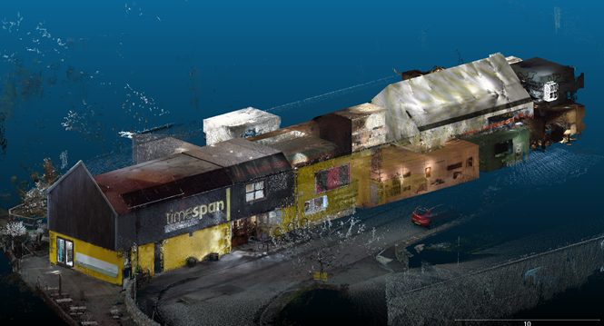
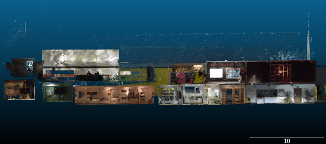
Figure 1 SLAM Point Cloud of the TimeSpan Museum
To complete the interior surveys, and to improve the external one drone-based photogrammetric approach was employed to document the TimeSpan Museum and its context. This methodology uses overlapping aerial images to reconstruct three-dimensional models with high geometric accuracy and realistic textures, making it ideal for capturing façades, roofs, and landscape elements. Carefully planned drone flights were carried out at an elevation of around 40 m during the meeting to ensure comprehensive coverage of the museum’s external surfaces. The aerial perspective provided access to areas that are difficult to document using ground-based methods, such as roof structures and upper façades. High-resolution imagery (Ground Sample distance < 1 cm) was collected following structured flight paths (nadir and oblique acquisitions), ensuring optimal overlap ( > 80%) and consistency.
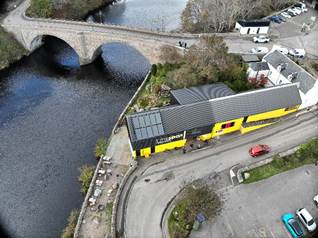
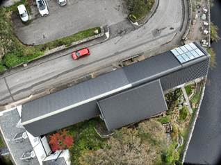
Figure 2 nadir (left) and obliquie image (right of the TimeSpan Museum)
The resulting photogrammetric models offer a visually rich and accurate representation of the museum’s exterior. These models not only document architectural details, but also situate the building within its environmental and urban context.
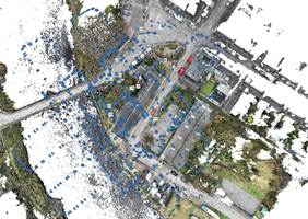

Figure 3 Images aligned (left) and used for the 3D model of the Museum (right)
Moreover the survey activities carried out at the TimeSpan Museum also provided an important opportunity to conduct initial tests on the use of Gaussian Splatting within the project, allowing the consortium to explore its potential for advanced 3D representation and visualisation of cultural heritage assets.
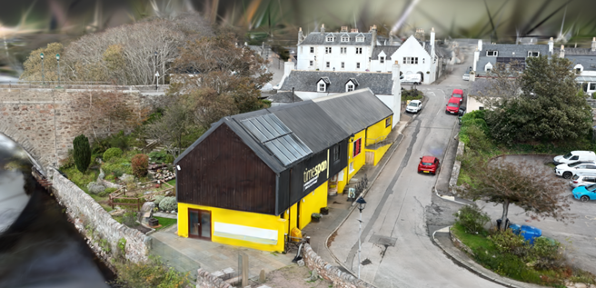
Figure 4 first test on the actual trend of digitisation using Gaussian Splatting
This broader spatial understanding is essential for interpretation and communication, reinforcing the museum’s identity within the landscape. For the photogrammetric adjustment and the georeferentiation of the drone-based acquisitions the same principle of the afore mentioned SLAM approach was followed, in order to ensure spatial consistency and accurate alignment between interior and exterior datasets.
One of the most significant achievements of the survey campaign was the integration of SLAM and drone photogrammetry data into a single, coherent digital dataset. This combined approach capitalizes on the strengths of each technology, delivering a comprehensive multi-scale representation of the TimeSpan Museum.
SLAM provided fast and efficient coverage of interior spaces, while drone photogrammetry contributed detailed exterior geometry and textures. Together, they form a complete digital record that supports a wide range of applications, from technical analysis and conservation planning HBIM creation and storytelling and public engagement.
The integration process also served as an opportunity for knowledge exchange among Heritalise partners. Discussions are still ongoing in order to addressed best practices in data alignment, quality control (accuracy) and model optimisation.
The digital outputs generated during the General Assembly offer significant benefits for the Museum. The 3D models provide a precise record of the museum’s current condition, contributing to long-term documentation and risk preparedness. In an era of increasing environmental and social challenges, such digital records are invaluable for safeguarding cultural heritage. From a management perspective, the models, carefully used in the generation of an HBIM or Digital Twin can support maintenance planning, spatial analysis, and exhibition development. Curators and managers can use digital data to explore scenarios virtually, reducing the need for physical interventions and supporting informed decision-making. Equally important is the potential for public engagement. The digital models can be used to create virtual tours, interactive experiences, and online resources that expand access to the museum. This enhances inclusivity and allows wider audiences to engage with heritage, regardless of physical or geographical constraints.
The achieved activities carried out during the Heritalise General Assembly transformed the event into a living laboratory for digital heritage. Participants were able to witness advanced technologies in real operation, bridging the gap between theory and practice. This hands-on experience strengthened shared understanding and inspired confidence in the use of SLAM and drone photogrammetry across different heritage contexts.
The Assembly became a space not only for strategic discussion, but also for experimentation, collaboration, and learning by doing. This approach reflects the core values of Heritalise, placing innovation and cooperation at the heart of cultural heritage digitalisation.
This initiative not only delivered high-quality digital outputs for the TimeSpan Museum, but also reinforced Heritalise’s mission to promote sustainable, accessible, and forward-looking approaches to heritage preservation. The activity proposed proved that when expertise, technology, and shared purpose come together, digital heritage can truly become a driver of innovation and impact.